

The History of the Landmarks and Trail Names in Cole’s Woods
By Bill Parks*
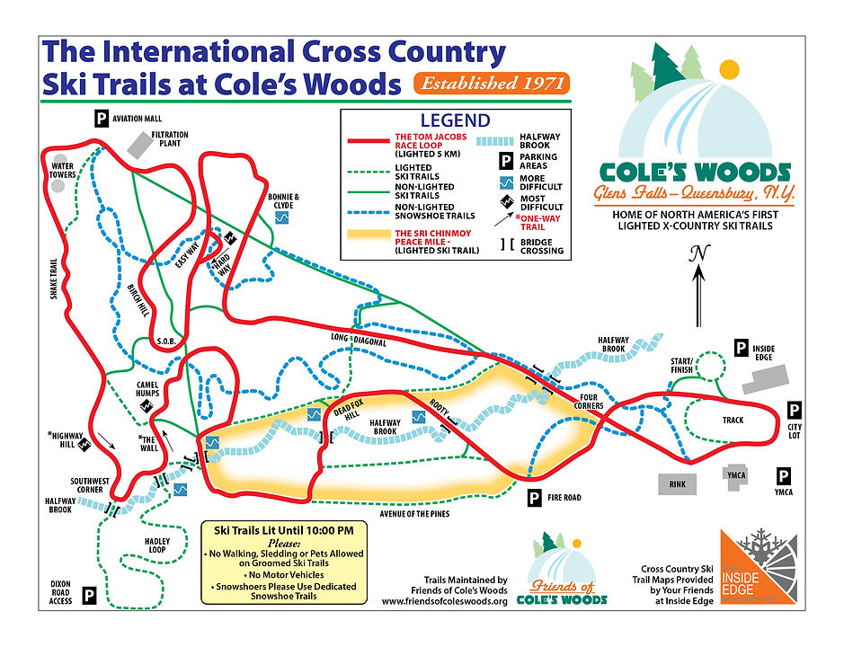
As one skis, runs, walks or bikes the trails in Cole’s Woods or studies the map of the trail system, they will notice that certain features are labeled. Knowing the names of these features and where they are located is useful when discussing one’s activities in the woods. “How do I get to the Four Corners?”, “I will meet you at the top of Bonnie and Clyde”, “My skis and I took an unexpected swim negotiating The Southwest Corner” or “My cardiologist was giving out business cards at the top of The Wall” are some samples of the usefulness of knowing the key landmarks. Here is a list as one encounters them going around the 5 kilometer ski loop. The derivations of most of the names are embarrassingly obvious. A couple of them are a little clever and several have a little history of interest. Clues to how a name was established and other history are italicized.
The YMCA Loop: Head around the YMCA track’s eastern end and out to The Four Corners. — Do you see the YMCA? Notice how the trail makes a loop….
The Four Corners: This is a major intersection in the woods behind the Y - check out the Tom Jacobs memorial erected for a former Olympian, who not only designed the trails and was an important local businessman, but also someone who heavily supported the trails for many decades! — As you stand there, look around, count the corners…get it?
The 1st Bridge: The bridges don’t have names. There are eight of them and I number them going upstream towards the Northway.
The Long Diagonal: About 150 yards after the first bridge, the main trail angles slightly to the left and goes straight and is pretty level for almost a quarter mile. — The debate is whether this piece of trail gets its name because it angles off the pipeline trail that runs from the YMCA to the filtration plant or because, in the days of wooden skis, most people used the diagonal stride, AKA single poling, along that stretch.
Bonnie and Clyde Hill: You are under a power line and can see the mall…or “the maul” as some of the disgruntled tagged it when a big chunk of Cole’s Woods vanished almost overnight. — As you stand looking at the mall, to your right there is a tiny sand pit. In the late 1960s Glens Falls High School’s cross country team’s running course came up the pipeline, turned into the sand pit and went up a short, steep sand bank to where you are standing. At the time, there was an abandoned car in the pit that gun-toting American youths had used extensively for target practice. The movie Bonnie and Clyde (1967) was fresh in the minds of the cross country runners and the name was born. The car is gone but the name remains.
Hard Way/Easy Way: Descending Bonnie and Clyde and skiing a short loop to the top of a steep bump, one comes to a fork in the trail. — On a day with fast snow conditions, ski down each of the trails…they rejoin in a couple hundred yards… and you will understand the name. If you are a new skier, maybe just take the sign’s word for it and take the Easy Way.
S.O.B.: This is a steep little uphill with a turn at the top that is difficult on classical skis. — “ S.O.B.” stands for son of a gun.
The Birch Hill: This is a longer uphill shortly after S.O.B. — This was cleverly named for a prominent birch tree at the top of the hill. The name has since become even more interesting since the tree fell after a storm and was fully cut down. Nowadays there is no birch tree to be seen.
Filtration Plant/ Water Towers: Also referred as The Invisible Water Towers — We call ‘em that because that’s what they are. Everyone was not happy with the decision to locate these facilities in the middle of a woodland recreation area. The cynics said, “It’s OK. They’re painting the water tanks green so you won’t even see them.” Hence, the alternative name.
The Snake Trail: From the high point of the trails to where one pops out of the woods under a power line crossing the Northway, the trail “snakes” its way down a long gradual slope.
Highway Hill: This is a fast downhill with a fast left turn at the bottom. — Well, you see, it descends right next to the highway…AKA The Northway.
The Southwest Corner: You are at what was the southwest corner of the park formed by Half Way Brook and the Northway and it does create a sharp turn on the 5 km. racing trail.
The Hadley Loop: If you cross the 8th bridge rather than turning left at The Southwest Corner, you go on to the unlighted .7 km. loop that serpentines almost to Dixon Road and back. It finishes down a steep bank, crosses the 7th bridge and a causeway and back onto the lighted trail. — Ruth Hadley lived on Dixon Road. She was a long-time resident who was interested in conservation and was a supporter of keeping Cole’s Woods protected for recreation. In her will, she expressed the wish that her land be sold to Glens Falls at a generously low price so that it could become part of the park. The loop name honors a generous and forward- thinking woman.
The Wall/Killer: After turning at the Southwest Corner and a short flat stretch along Half Way Brook, the trail turns left and you are facing the biggest uphill on the course. — Stop about 1/3 to half way up the hill. Look at the steepness of the hill 20 yards to either side of the trail. That is how steep the trail was for the first four or five years the trail was used. It was so steep that good skiers couldn’t pass less experienced ones, thus creating unfair delays. Bulldozers were called in to create today’s more reasonable slope which is still nasty enough to warrant the alternative name.
The Camel Humps: Holy Bactrian, Batman! The top of the Wall/Killer is one hump, you drop like a rock, make a slight turn and climb and go down the second hump and into the woods. — After a few hundred yards, you descend to cross the brook on the 5th bridge. Turning left, the trail runs next to houses at the ends of Dixon Court and Northrup Drive, turns left again and descends to the 4rth bridge. Crossing the bridge the trail bends to the right and you climb…
Dead Fox Hill: This hill was named by Queensbury High School athletes because…guess what they found there! — The Glens Falls High School ski team had proposed the name Bustard Hill. A bustard is a large African bird never seen in Cole’s Woods. The team, I fear, thought the name was a nice companion with S.O.B. in that they both sound slightly naughty. Thankfully, good taste has prevailed!
Rooty Hill: A few hundred yards after the top of Dead Fox, the trail turns right and you descend Rooty. — In the early 1970’s the Glens Falls High School cross country running team revised its home course and racers climbed this hill twice. The first time up runners turned left at the top. The second time, they went right. The rules allowed one to stay on the smooth trail that we ski down or take the shorter but steeper path over a series of large roots. Rooty…get it?
So, go up past the Parkview/Fire Road parking area, swing left and you are back to The Four Corners and the YMCA Loop.
Daniel Boone is alleged to have said, “I never got lost but I do admit to having been confused for a couple of days a few times.” Here are a few thoughts for those of you who get confused in Cole’s Woods:
-
With the exception of The Hadley Loop, the trail system fits into a rough triangle. The short side of the triangle is the Northway at the west end. The north side is next to the Aviation Mall, the Foster Avenue condominiums and Price Chopper (Market 32). The south side abuts the residential streets Dixon Court, Northrup Drive, Bullard Avenue, Linden Avenue and the Fire Road. The track by the YMCA is the point where the north and south sides meet.
-
To get your bearings, let’s skip the sun, stars and carrying a compass. Stop and get quiet and listen! You will either immediately, or very soon, hear traffic noise from the Northway. Face that way and you are looking west. Turn around and you are aiming east towards where most people park.
-
Not sure you are going in the right direction? Half Way Brook runs down the middle of the trails. Find a bridge. The brook flows from the Northway downstream to the east.
-
Look for trail maps at major intersections for additional help.
Finally, if you have an emergency and need help in a hurry and can’t see anything but woods, orient yourself with the Northway and take trails that go to the south. You will usually come to houses in less than 500 yards.
Have fun exploring and don’t get lost…oops! I mean confused.

*About Bill Parks
Bill Parks was a high school social studies teacher at Glens Falls High School for 32 years. For many of those years he was a three season coach. Coaching cross country running, track and Nordic skiing, Bill had considerable success motivating young people to participate and excel in sports.
In that setting, he strove to teach the reward and fun of working hard toward challenging goals. He stressed the importance of good sportsmanship, an athlete’s role on a team, a love of the outdoors, as well as many bigger life lessons.
Both as an athlete and as a coach, Bill was drawn to Crandall Park and the trails in Cole’s Woods. He and his athletes trained and raced there. He learned to cross country ski there, worked to enlarge the trail system and encouraged the growth of cross country skiing in our area. He was an early member of The Friends of Cole’s Woods and a long time volunteer trail groomer.
Participating in the Birkebeiner ski race in Norway as a fund raiser is his way of repaying Cole’s Woods for the decades of fun, excitement and rewarding recreation he has enjoyed there. It is also a way for all of us to say thank you for the good work of The Friends of Cole’s Woods and encourage the continuing maintenance and protection of our community treasure.